2011 Mt Assiniboine Pack Trip
|
This was a 6 day pack trip with 2 riders, 4 horses, 1 Jimmy dog and a 2nd dog friend. It was an awesome loop ride from Mitchell River over Ferro Pass, up Simpson River, past the spectacular lakes and down the Mitchell River again. The trip was published in Saddle Up magazine in July 2012 as Mt Assiniboine Loop Ride. See text below. To do this trip, buy Pack'em Up, Ride'em Out |
During the 2011 Spruce Meadows Masters, Wendy and I decided to do a pack trip - if we could agree on a location between the Kootenays where her horses were, and Prince George where mine were. Fortunately, Mount Assiniboine was on both our hit lists and ten days after our conversation we started a six day ride.
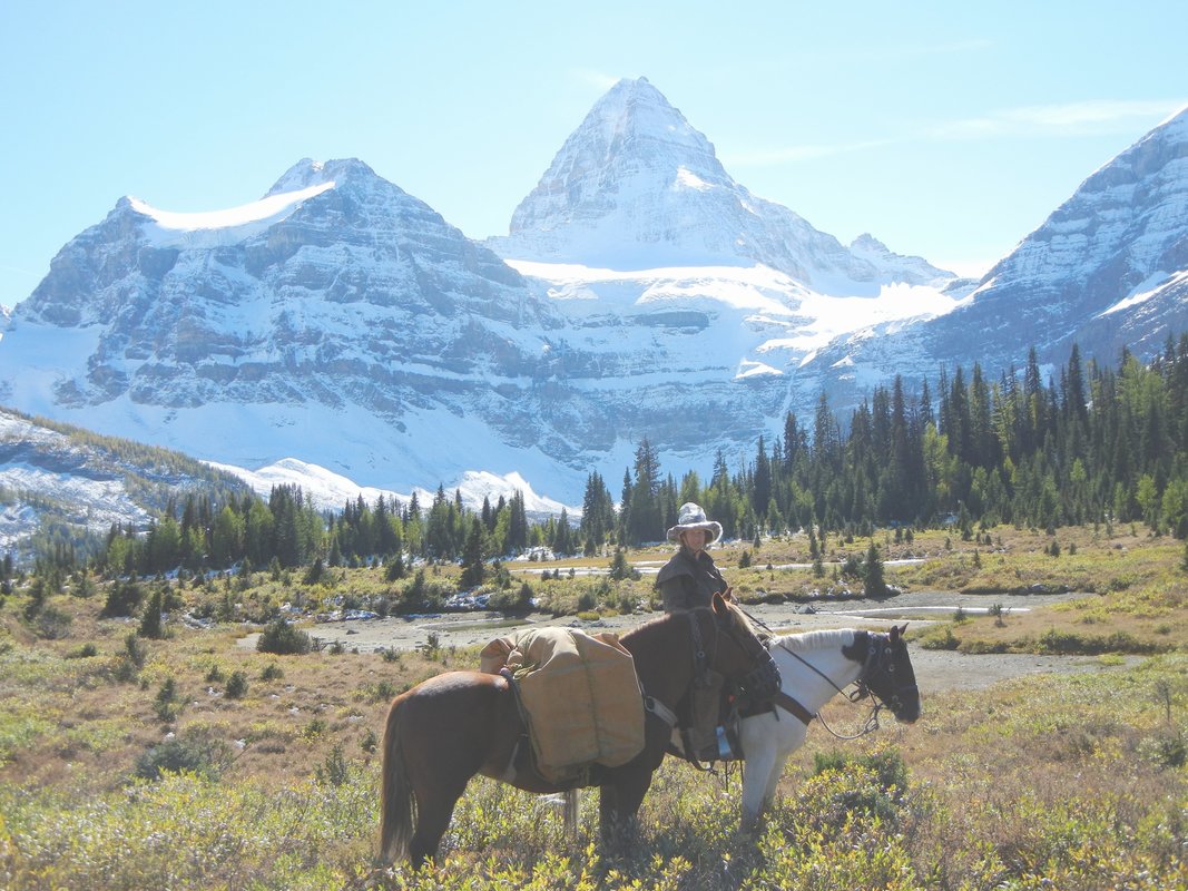
Mount Assiniboine is located in the triangle between Banff, Canmore and Radium Hot Springs, on the BC side of the continental divide. The peak soars over 3,600 m and with its distinctive pyramid shape is one of the most recognizable peaks in the Rockies. Historically, First Nations used the area extensively, which is documented in photos of tipis situated on the shores of Lake Magog. Early explorers, mountaineers and tourists accessed the area by horse and in 1922, the area was designated a provincial park. Commercial horse pack trips are not currently available to the park, which is used almost exclusively by hikers. However, permission to ride horses in the park is easily acquired from BC Parks.
Accessing the park by road is more challenging. Horse access is via the southeast (Spray Lakes and Bryant Creek), north (Brewster Creek), or southwest (Highway 93 to Baymag Mine and Mitchell River). Due to a fire in 2003, the easiest access - via the Simpson River - is not yet possible. We chose the Baymag Mine road, and I endured the distinct unpleasantness of meeting five(!) ore haul trucks in 42 km of narrow gravel road.
Our loop ride took six days including one rest day. It could easily have been extended, but late September weather kept us moving. The Banff & Mount Assiniboine Hiking Map was suitable for trail finding and a topo map helped with the Simpson River portion of the route.
The Mitchell River trail starts from an outfitters shack in the middle of a clearcut. After a short bushwack down to the river, the trail was straightforward, although it hadn’t been cleared in some time. Our first camp was at a BC Parks shelter, which had one night’s worth of grazing. The second day we headed up to Ferro Pass in rain and snow. The trail had been ribboned a few years back, which kept us on-route when we couldn’t see the trail for the white stuff. The trail down the north side of the pass was wide and easy travelling, and the BC Parks cabin and well built corral at the Simpson River/Surprise Creek junction almost made up for the poor grazing.
The 16 km route along the Simpson River might cause some riders grief. The western portion of the route follows the river bed and gravel bars. From Scout Camp east, the horse trail is on the south side of the river. Aside from a bit of confusion about how far along we were, we didn’t have any trouble. However, from logbook notes, I suspect that an earlier group of riders tried to avoid the riverbed and follow an uncleared trail.
Riding into Police Meadows in pouring rain, our eyes bugged out. It’s an absolutely stunning five acres of knee-high grazing surrounded by mountains. BC Parks has done a superb job keeping invasive weeds out, and the cabin is in great condition for an old-timer. It was the perfect place for a rest day, and after getting snow overnight, we were happy to hang out.
With sunny skies the next morning, we decided on a 24 km day. The trail went southeast up Valley of the Rocks, which is a rather bizarre jumble of, well, rocks, then south through lovely meadows towards Magog Lake. The views of Mount Assiniboine in fresh snow and sunshine were eye-popping. A grizzly bear startled the dogs but not the horses, and we saw hardly any hikers. Horses are restricted to a trail that skirts the lakes, and we followed it west to complete our loop. Our last campsite was a meadow with a view of the west face of Mount Assiniboine glowing pink in the setting sun. Lovely.
We had a great trip and Wendy’s off the track thoroughbreds did just fine. So if you’re looking for a straightforward week long pack trip in a stunning location, I’d recommend Mount Assiniboine. It’s a bit out of the way, but well worth the effort.
